Home![]() books
books
![]() ecology
ecology![]() Latest info
Latest info![]() from space
from space
![]() Encyclopedia
Encyclopedia![]() Animals
Animals![]() Plants
Plants![]() Climat
Climat![]() Research
Research![]() The world beneath Baikal
The world beneath Baikal![]() Geology
Geology![]() Circumbaikal railroad
Circumbaikal railroad![]() Photogallery # 1
Photogallery # 1![]() Photogallery # 2
Photogallery # 2![]() Photogallery # 3
Photogallery # 3![]() Listvyanka
Listvyanka![]() Natives
Natives![]() In German
In German![]() Word of poet
Word of poet![]() Olkhon island
Olkhon island![]() Earthwatch
Earthwatch
![]() Shopping
Shopping![]() Travel agences
Travel agences![]() Guestbook
Guestbook
![]()

 On
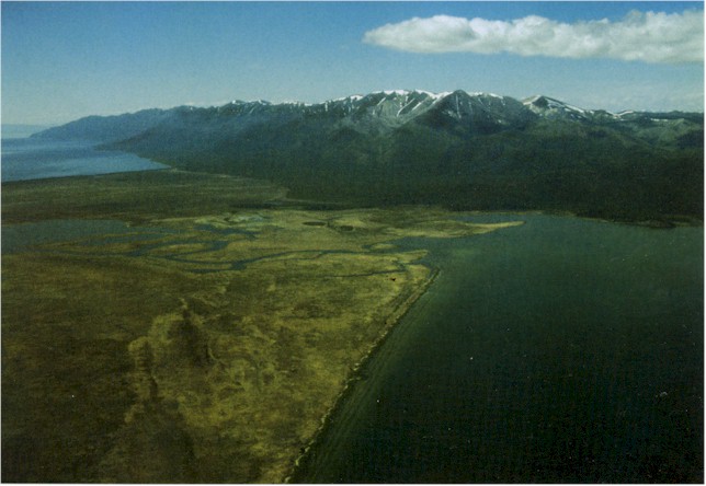
all sides the Baikal hollow is surrounded by mountains: on the western shore
the lake is closely rimmed by the Primorsky and Baikalsky Ranges, with their
maximum height of 2,678 metres.
On
all sides the Baikal hollow is surrounded by mountains: on the western shore
the lake is closely rimmed by the Primorsky and Baikalsky Ranges, with their
maximum height of 2,678 metres.
On the eastern side, Baikal is fringed by the Barguzinsky and Ulan-Burgasy Ranges, and in the south and south-east by the Khamar-Daban Range, with its summit named Munku-Sardyk (eternally snowy) reaching 3,491 metres above sea level. The tops of the ranges and the valleys of the rivers flowing down the Baikalsky, Barguzinsky, Khamar-Daban Ranges, evince rather distinct traces of local mountain-valley glaciating. The last 250 thousand years witnessed not less than 5 serious cold spells, and the last one only 10-15 thousand years ago.
 The
northern part of Lake Baikal is the shallowest, with a maximum depth of
890 metres. Baikal and the mountains surrounding it came into existence
due to fracturing and movement of the earth's crust, resulting from tension
inside the Earth itself. The major geologic feature of the Baikal Territory
is that it incorporates the borderline of the great tectonic structures
- the Siberian platform and its framing and the Sayano-Baikalsky folded
belt. Tectonic movements along this border never cease and are manifested
by earthquakes and by fluctuations of separate parts of the shores. Annually,
the ground seismic stations register up to 2,000 earthquake tremors; the
most sensitive seismographs, installed at various depths of the lake, identify
them more frequently. In 1862, north of the Selenga's delta, an area of
land of about 200 square kilometres sank under water to a depth of 2 metres
as the result of an earthquake whose magnitude, as A. Voznesensky stated,
reached magnitude 11. (This compares to the magnitude 10 quake in Ashkhabad
in1948, and the magnitude 7 in Tashkent in 1967). The new bay formed on
Baikal by the 1862 earthquake was called Proval (gap), and the new water-ways
that broke through, the Cape - Oblom (Break-On).
The
northern part of Lake Baikal is the shallowest, with a maximum depth of
890 metres. Baikal and the mountains surrounding it came into existence
due to fracturing and movement of the earth's crust, resulting from tension
inside the Earth itself. The major geologic feature of the Baikal Territory
is that it incorporates the borderline of the great tectonic structures
- the Siberian platform and its framing and the Sayano-Baikalsky folded
belt. Tectonic movements along this border never cease and are manifested
by earthquakes and by fluctuations of separate parts of the shores. Annually,
the ground seismic stations register up to 2,000 earthquake tremors; the
most sensitive seismographs, installed at various depths of the lake, identify
them more frequently. In 1862, north of the Selenga's delta, an area of
land of about 200 square kilometres sank under water to a depth of 2 metres
as the result of an earthquake whose magnitude, as A. Voznesensky stated,
reached magnitude 11. (This compares to the magnitude 10 quake in Ashkhabad
in1948, and the magnitude 7 in Tashkent in 1967). The new bay formed on
Baikal by the 1862 earthquake was called Proval (gap), and the new water-ways
that broke through, the Cape - Oblom (Break-On).
 Before
the quake, old people describe the area of Proval as the Sagan-Moryan (White
Steppe), upon which were five Buryat uluses (villages) that gave residence
to 1,200 aborigines with their 867 houses and yurts (tents), and more than
17,000 head of cattle. On the New Year's eve (old style) the residents heard
a subterranean boom, and water mixed with sand and silt began splashing
out of the wells. The frightened people drove off the cattle to more elevated
parts of the foothills, but the shaman Petrushka, who enjoyed great respect
and indisputable authority, persuaded the people to go back to the steppe,
in order to accept the penalty of Burkhan - the god of Baikal. That night
when the water came flooding over the steppe, people forced their way to
the high shore using either gates torn off their Tiinges, or plain logs.
All property and livestock perished.
Before
the quake, old people describe the area of Proval as the Sagan-Moryan (White
Steppe), upon which were five Buryat uluses (villages) that gave residence
to 1,200 aborigines with their 867 houses and yurts (tents), and more than
17,000 head of cattle. On the New Year's eve (old style) the residents heard
a subterranean boom, and water mixed with sand and silt began splashing
out of the wells. The frightened people drove off the cattle to more elevated
parts of the foothills, but the shaman Petrushka, who enjoyed great respect
and indisputable authority, persuaded the people to go back to the steppe,
in order to accept the penalty of Burkhan - the god of Baikal. That night
when the water came flooding over the steppe, people forced their way to
the high shore using either gates torn off their Tiinges, or plain logs.
All property and livestock perished.
On the 29th of August 1959, during an earthquake of magnitude 9, the Baikal bottom was displaced for 12-20 metres.
Home![]() Books
Books ![]() Ecology
Ecology![]() Latest
info
Latest
info
![]() from
space
from
space ![]() Encyclopedia
Encyclopedia
![]() Animals
Animals![]() Plants
Plants![]() Climat
Climat![]() Research
Research![]() The world beneath Baikal
The world beneath Baikal![]() Geology
Geology![]() Circumbaikal railroad
Circumbaikal railroad![]() Photogallery # 1
Photogallery # 1![]() Photogallery # 2
Photogallery # 2![]() Photogallery # 3
Photogallery # 3![]() Listvyanka
Listvyanka![]() Natives
Natives![]() In German
In German![]() Word of poet
Word of poet![]() Olkhon island
Olkhon island
![]() Earthwatch
Earthwatch
![]() Shopping
Shopping![]() Travel agences
Travel agences![]() Guestbook
Guestbook
realvideo
![]() Transsiberian
railway.
Transsiberian
railway.![]() Inside
the train at Transsiberian railway,download .mov 468kb
Inside
the train at Transsiberian railway,download .mov 468kb![]() Circumbaikal
railway
Circumbaikal
railway![]() Lake
Baikal beauty
Lake
Baikal beauty![]() Yachts
at Baikal
Yachts
at Baikal![]() Brown
bears at lake Baikal shores in spring
Brown
bears at lake Baikal shores in spring![]() Aqualangist
under Baikal ice
Aqualangist
under Baikal ice![]() At
lake Baikal beneath
At
lake Baikal beneath![]() Baikal
nerpas
Baikal
nerpas![]() History
of Trans-Siberian
railway
History
of Trans-Siberian
railway
![]()
|
|
|
|